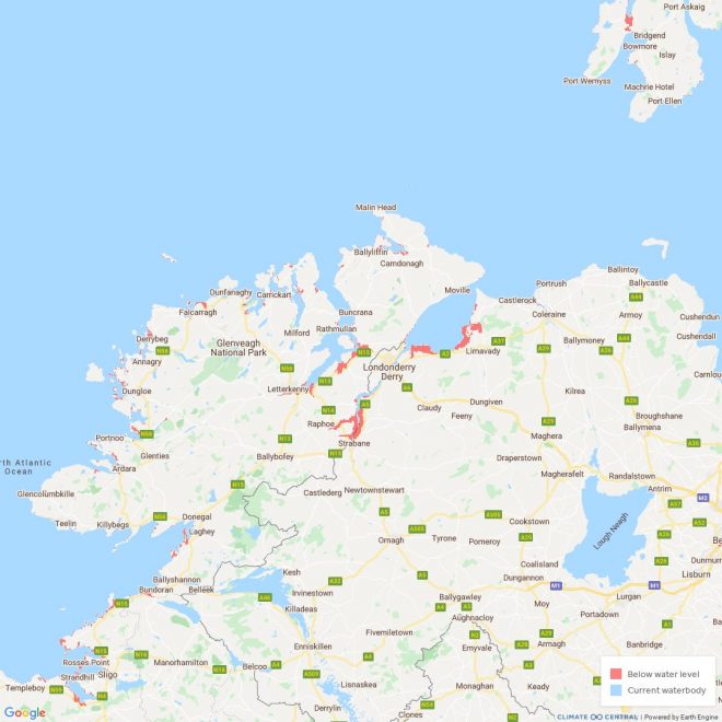
WITH sea levels continuing to rise, vast swathes of coastal Donegal could be submerged underwater by 2030 if action on climate change is not taken.
A recent UN report, which was released by the Intergovernmental Panel on Climate Change (IPCC), said temperature rise will hit 1.5C by 2040 even in the best care scenario where greenhouse gas emissions are reduced.
A special map has been produced to show the effect of climate change on Ireland by 2030, and it makes for worrying viewing.
Sections of Letterkenny, Lifford, St Johnston and An Grianan Estate in Burt are under serious threat, while coastal areas all over the county are at risk of being permanently flooded in the next decade or so.
The report has been labelled a “code red” by Taoiseach Michéal Martin, who urged the world to “act fast” in order to save the planet.
The research has been carried out by Climate Central, a non-profit science organisation based in New Jersey, USA. They have explored the sea level rise and coastal flood threats that face our county.
The maps are projections and the data sets are not perfect, but as Climate Central states “these maps should be regarded as screening tools to identify places that may require deeper investigation of risk.”
The map gives a detailed insight of what Letterkenny will look like if temperatures rise by two degrees and if they rise by four degrees.
Much of the town would be underwater with a two per cent rise in temperatures including the Neil T Blaney Road and large sections of the Port Road.
ST JOHNSTON TO LIFFORD
Long stretches of the River Foyle from St Johnston to Lifford are under threat while in the Creeslough and Falcarragh areas large parcels of land are projected to be below the tideline in 2030.
Under these predictions, Magheraroarty and pockets of Bloody Foreland are at risk as the islands of Gola. Tory and Arranmore.
Indeed, Magheraroarty could well be cut off from the mainland by 2030 while sections of the N56 between Portnablagh and Dunfanaghy are under threat.
Lands forming much of Letterkenny Golf Club are also at risk as are large tranches of coastal parts of Carrickfinn, including Donegal Airport.
THE ROSSES
Moving further into Keadue and the Rosses and areas around Belcruit, Burtonport, Maghery, Meenacross and Inishfree Island are under threat, according to the map.
Another golf club likely to be affected by further coastal erosion is Narin and Portnoo links while Assaranca Waterfall, a popular tourism spot outside Ardara, may well be flowing straight into the bay in less than ten years time.
The local Ardara GAA club grounds at Kentucky, Magheragallon, home to Gaoth Dobhair and Naomh Coulmba’s facilities in Glencolmcille are just three sporting facilities also under threat of permanent flooding.
The results are based on if the global temperature rises 2 degrees in the coming years with climate scientists predicting this rise will take place in the next decade.
“For the first time, the IPCC have broken these impacts down to a regional level, showing that climate change will affect us all,” Martin said.
“Our ways of life – urban, coastal and rural – will all be impacted by climate change, with increasingly devastating consequences for lives, livelihoods and nature unless immediate action is taken.”
Minister Eamon Ryan said that the report was a ‘stark reminder’ of the limited time available to prevent further negative consequences from climate change.
“For Ireland and Europe the report predicts more intense heat waves and increased flooding as temperatures rise. If global temperatures rise by more than 2 degrees above pre-industrial levels there will be critical consequences for agriculture and health,” he said.


